
TERRAIN, TERRAIN, TERRAIN!!!!!

Those words all by themselves are relatively benign — but when a pilot hears them in a headset, it is enough to cause an increase in heart rate and send their blood pressure into the stratosphere. Helicopters are usually flown low to the ground and the nature of a helicopter pilots’ work takes them into some hazardous flying environments. Since the time of the Wright Brothers and Igor Sikorsky, aircraft safety rules have been written in blood. Over the years, vast improvements in aircraft design and instrumentation have made flying and helicopter flying, in particular, safer. Sandel HeliTAWS is one of those improvements that helps pilots avoid controlled flight into terrain (CFIT.)
A Little Background
Beginning in the early 1970s, a number of studies looked at the occurrence of CFIT accidents wherein a properly-functioning airplane under the control of a fully-qualified and certificated crew is flown into terrain, or water, or obstacles with no apparent awareness on the part of the crew. Findings from these studies indicated that many such accidents could have been avoided if a warning device called a ground proximity warning system (GPWS) had been used. As a result of these studies and recommendations from the U.S. National Transportation Safety Board (NTSB), the FAA required all Part 121 certificate holders (those operating large turbine-powered airplanes), and some Part 135 certificate holders (those operating large turbojet airplanes), to install TSO-approved GPWS equipment in 1974.
In 1978, the FAA extended the GPWS requirement to Part 135 certificate holders operating smaller airplanes, i.e., turbojet-powered airplanes with ten or more passenger seats. These operators were required to install TSO-approved GPWS equipment or alternative ground proximity advisory systems that provide routine altitude callouts, whether or not there is any imminent danger. This requirement was considered necessary because of the complexity, size, speed and flight performance characteristics of these airplanes. The GPWS equipment was considered essential in helping the pilots of these airplanes to regain altitude quickly and avoid what could have been a CFIT accident.
Installation of GPWS or alternative FAA-approved advisory systems were not required on turboprop-powered airplanes operated under Part 135 because, at that time, the general consensus was that the performance characteristics of turboprop airplanes made them less susceptible to CFIT accidents. For example, it was thought that turboprop airplanes had a greater ability to respond quickly in situations where altitude control was inadvertently neglected, as compared to turbojet airplanes. However, later studies, including investigations by the NTSB, analyzed CFIT accidents involving turboprop airplanes and found that many of these accidents could have been avoided if GPWS equipment had been used. In 1992, the FAA amended §135.153 to require GPWS equipment on all turbine-powered airplanes with ten or more passenger seats (57 FR 9944, March 20, 1992).
After these rules were issued, advances in terrain mapping technology permitted the development of a new type of ground proximity warning system that provides greater situational awareness for flight crews. The FAA has approved certain installations of this type of equipment, known as the enhanced ground proximity warning system (EGPWS). However, in the proposed final rule, the FAA is using the broader term terrain awareness and warning system (TAWS) because the FAA expects that a variety of systems may be developed in the near future that would meet the improved standards contained in the proposed final rule.
TAWS
TAWS works by using digital elevation data and airplane instrumental values to predict whether or not a likely future position of the aircraft will intersect with the ground. The flight crew is then provided with “earlier aural and visual warning of impending terrain. Forward-looking capability, and continued operation with the aircraft in its landing configuration is also accomplished.”
There are three types or levels of TAWS specifications approved by the FAA, Class A TAWS, Class B TAWS and Class C TAWS. The FAA specifications have detailed requirements for when certain warnings should sound in the cockpit.
Class A TAWS includes all the requirements of Class B TAWS below, and adds the following additional three alerts and display requirements:
• Excessive closure rate to terrain alert
• Flight into terrain when not in landing configuration alert
• Excessive downward deviation from an ILS glideslope alert
• Required: Class A TAWS installations shall provide a terrain awareness display that shows either the surrounding terrain or obstacles relative to the aircraft, or both.
Class B TAWSis defined by the FAA as:
A class of equipment that is defined in TSO-C151b and RTCA DO-161A. As a minimum, it will provide alerts for the following circumstances:
• Reduced required terrain clearance
• Imminent terrain impact
• Premature descent
• Excessive rates of descent
• Negative climb rate or altitude loss after take off
• Descent of the airplane to 500 feet above the terrain or nearest runway elevation (voice callout “five hundred”) during a non-precision approach
• Optional: Class B TAWS installation may provide a terrain awareness display that shows either the surrounding terrain or obstacles relative to the aircraft, or both.
Class C TAWS defines voluntary equipment intended for small general aviation airplanes that are not required to install Class B equipment. This includes minimum operational performance standards intended for piston-powered and turbine-powered airplanes, when configured with fewer than six passenger seats (excluding any pilot seats). Class C TAWS equipment shall meet all the requirements of a Class B TAWS with the small aircraft modifications described by the FAA. The FAA has developed Class C to make voluntary TAWS usage easier for small aircraft.

HeliTAWS
Sandel HeliTAWS brings the benefits of a terrain avoidance system to helicopter operators so they can avoid CFIT. Combining its TAWS expertise from thousands of installations in private, corporate and air-transport airplanes and years of supplying civilian and military users with its three- and four-inch primary displays, Sandel introduced HeliTAWS in 2010. Certified to the new HTAWS TSO-C194 specifically for helicopters, HeliTAWS combines an advanced HTAWS computer with a single-panel mount, self-contained solution. HeliTAWS differs from its fixed-wing counterpart with the following features designed specifically for helicopters:
• Ultra-high resolution three arc-second (300 foot x 300 foot) terrain grid
• One-foot vertical obstacle resolution
• High-resolution obstacle database
• On-screen obstacle depiction
• Nuisance al–ert reduction tailored for helicopter operations
• WireWatch main transmission line alerting/warning capability
• Aural decent altitude callouts when interfaced to a radar altimeter
The ultra-high-resolution display clearly shows identifiable obstacles and GPS flight plans. It is also a TSOd traffic indicator when interfaced to an existing traffic advisory system (TAS) or traffic collision avoidance system (TCAS.) It is also capable of displaying radar altitude, all in a nice, neat package with a more than 10,000-hour mean time between failure (MTBF.)
For missions flown using night vision goggles, HeliTAWS can be ordered with Sandel’s proprietary on-demand Mil-Std-3009 NVIS option. Unlike aftermarket NVIS modifications, Sandel’s unique NVIS mode employs no external filters and does not degrade its brightness or daylight visibility when NVIS is “off.”
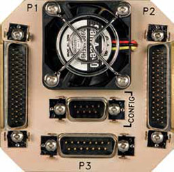
For those requiring additional capability, HeliTAWS supports GPWS Modes 1, 3, 4, 5 and 6. Sandel has perfected the 3ATI format along with ultra flexible avionics interfaces. Panel space is at a premium in helicopters and the self-contained 3-ATI size allows the ST3400H to be installed in the place of an existing radar altimeter indicator. This means less modification, less cost and less downtime. No remote black boxes involved.

Maintenance Department Questions and Answers
HeliMx– In addition to what was described earlier, how has the display been optimized for helicopter operations?
Sandel– The display features a 180-degree vertical and horizontal viewing angle. If a radar altimeter is interfaced, HeliTAWS generates audio descent altitude callouts all the way to touchdown.
HeliMx – Is there a particular sensor package that is required for the system?
Sandel– The short answer is no. HeliTAWS simply connects to a qualified GPS and heading system in the helicopter. The remaining connections are audio for alert callouts and, of course, power and ground connections.
HeliMx– Can the system work with analog and digital inputs?
Sandel– The GPS typically uses an RS-232 connection. Heading data can come from an Aeronautical Radio Incorporated (ARINC) 407 analog synchro or over an ARINC 429 digital bus. The optional radalt input can be either analog or digital, and the TAS and TCAS inputs are ARINC 429.
HeliMx– Who owns the installation supplemental type certificate (STC)?
Sandel– We do, and we share the data with our customers, at no cost, as required.
HeliMx– Who typically would perform an installation?
Sandel– Normally it would be an authorized Sandel dealer. In the case of large fleet operators, they may have the capabilities to perform their own installations.
HeliMx– Are there any special electrical or mechanical considerations in doing an installation?
Sandel – No, any qualified avionics technician should be able to do the installation.
HeliMx– Does the system employ built-in test (BIT)? Is any special test equipment required by the end user?
Sandel – HeliTAWS employs an internal flight recorder for data retrieval during troubleshooting, and no special test equipment is required by the end user.
HeliMx– How is system programming accomplished in the field?
Sandel– A mini-USB cable is connected between the unit and a laptop computer.
HeliMx– What is recommended to clean the display?
Sandel – A 50/50 isopropyl alcohol/water mix and a soft, lint-free cloth, the same as what is used to clean polycarbonate-lens eye glasses. Never use ammonia and anything that is abrasive and can scratch the anti-glare coating on the display.
HeliMx– How is the unit cooled?
Sandel – Cooling is accomplished through the use of a built-in fan and ventilation system. No additional cooling is required.
HeliMx– What tests can be performed in the field to assure the system is operating properly?
Sandel – Verify and monitor alerts in VFR conditions for accuracy.
HeliMx– How often does the unit need to be removed for testing?
Sandel – It doesn’t. Removal is done on condition.
HeliMx– Are there any scheduled servicing tasks required?
Sandel– None required other than periodic database updates.
HeliMx– Is the unit repairable in the field?
Sandel – No, all repairs are performed at our facility in Vista, CA.
HeliMx– What is the system’s return-to-service procedure?
Sandel– Follow normal acceptable standards for re-installing the unit in the aircraft. Apply power to the unit and verify normal screen and display presentations.
HeliMx– From an installation standpoint, what tips and lessons learned can you share with our readers?
Sandel– The following information should prove helpful, but for any questions on installing or troubleshooting the system, please contact Sandel Product Support at
1-877-726-3357 or email us at support@sandel.com.
• Make sure the placement of the ST3400H is in easy reach of the pilot/copilot
• Check the depth of the area where you will be installing the ST3400H to make sure the unit will fit flush in the panel and the connectors on the back of the rack have plenty of clearance
• Determine what will be your position source; at this time, we have certified the Garmin GNS 400/500 series with or without wide area augmentation system (WAAS) Freeflight 1201 WAAS sensor and the Garmin GTN 650/750 Series
• If a General Aircraft Manufacturers Association (GAMA) Flight Plan is desired, then the following are certified: Garmin GNS series, King KLN-89, 90 & 94 and the Trimble 2101
• The heading input can either be ARINC 407 (XYZ)
or ARINC 429 (low or high speed)
• Air data (if used) can be analog like the Honeywell AZ-649 or ARINC 429 data (high or low speed)
• You can set the discrete input page as needed for back course, gear and NVIS control
• Our output pins, page six, can be used to set for the desired action for TCAS inhibit, radar altimeter self-test, minimums and other warnings if needed as per the installation manual
• Interfacing a nav system for localizer and glideslope information can be either analog or ARINC 429
• For enhanced ability on the HeliTAWS, a radar altimeter is recommended
• If you wish to display a traffic system, you will have to interface the system via ARINC 429; you will also be required to purchase a TCAS key code for this feature to work
• Make sure any external switch installation is easily accessible for the pilot and copilot
• Make sure you fully understand the audio input to the aircraft audio amplifier; make sure of a good shield ground for the audio to eliminate unwanted noise in the system.
With Sandel HeliTAWS, helicopter operators can now also enjoy the benefits of improved safety in-flight and minimize the dangers of controlled flight into terrain and obstacles.